Plans
Maps, plans, architectural and technical drawings
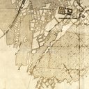
| Image | Code | Title | Type | Description |
|---|---|---|---|---|
|
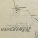
LVSAV1984.013 | Plan - Niddry Castle bing, 1962 | File Record | Coloured plan showing plot of land at Niddry Castle bing dated 21/3/62 |
|
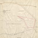
LVSAV1984.014 | Plan - Niddry Castle bing, 1956 | File Record | 1/2500 plan showing lands near Niddry Castle bing |
|
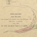
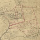
LVSAV1984.015 | Plan - Niddry Castle bing, 1928 | File Record | Plan of Niddry Castle bing showing extensions 1923-28, route of haulage and proposed tipping platform |
|
LVSAV1984.016 | Plan - Niddry Castle bing, 1947 | File Record | 25" = 1 mile coloured plan, showing land for extension of Niddry Castle bing, |

|
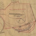
LVSAV1984.017 | Plan - height survey of Niddry Castle bing * | File Record | Coloured plan of outline and heights of Niddry Castle Works spent shale bing, on thick paper |
|
LVSAV1984.018 | Plan - extension of Niddry Castle bing, 1930 | File Record | O.S. map, marked up to show sequence of extension of Niddry Castle bing. |
|
|
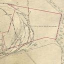
LVSAV1984.019 | Plan - boundaries of Craigton Farm* | File Record | 6" OS map, 1958 edition, showing Craigton Farm boundaries edged in blue, |
|
LVSAV1984.020 | Plan - level and extensions of Niddry Castle bing, 1961 | File Record | 25" OS map, 1917 edition marked up to show land boundaries and level of Niddry Castle Works bing |
|
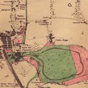
LVSAV1984.021 | Plan - land occupied in Hopetoun estate, 1962 | File Record | OS 6" map, marked up to show oil company lease boundary |
|
LVSAV1984.022 | Plan - mine abandonment plan Duddingston No.1, 1942 | File Record | Underground mine abandonment plan, Barracks shale seam, Duddingston No 1 Mine, 1942 |